I had a call out of the blue the other night. Joe, a childhood friend, and two hiking partners were going to travel three hours to climb Balsam and Eagle Mountains, both Catskill high peaks. The meeting place would be the McKinley Hollow Trailhead. I pondered but did not commit – and even indicated chances were slight. But with a day to let it sink in, the hiking bug soon got the best of me, surprise, surprise. I hatched a plan to participate. I would climb Balsam from the closer (to me) Rider Hollow Trailhead, meet them at the summit, and skip the jaunt out to Eagle, which also includes Haynes Mountain along the way. Although I never take living in the Catskills for granted, the fact that these guys would be spending six hours (and maybe more) in a car to hike here only reinforced my appreciation for having Rider Hollow in my greater backyard.
The last thing Joe and I agreed to in our land-line conversation was that he would text me from the Kingston interchange of the thruway, for timing purposes. (Yes, I now have an iPhone - that’s another story). Unbeknownst to me at the time, my efforts to explain the Plan-B summit meeting to him via text failed. Fortunately, I received his text, probably as I drove over the higher elevations on the way to Rider Hollow. At the trailhead, my screen said of his text: “24 minutes ago.” Was that sent? Received? And how long was that message bouncing around in the mountains? Ah well, I harbored an optimism, borne of thinking I’d be ahead of them. From Rider Hollow, Balsam Mountain is a 5.3-mile loop hike with about 1,700 feet of elevation gain. It’s challenging but it comfortably fits within a half day. The loop option, being relatively rare for a Catskills five-miler, contributes to the popularity of this hike. And at 3,600’ feet, the mountain is a requirement for those collecting hikes to all the high peaks. Plus, there’s an amazing view. If you haven’t tried this hike, take Dry Brook Road 4.6 miles out of Arkville and follow the brown-and-white wayfinding signs.
Although vehicular access terminates at the trailhead, the old road continues much farther into the hollow as a trail. Evidence of prior human settlement is found along the way and former structures are shown on old USGS topographic maps (see the USGS Historical Topographic Map Explorer). In the summer, the occasional Bee Balm flower will signal the location of a former homesite. Another interesting piece of human history is the metal bridge you encounter near the Rider Hollow Lean-to. The material was taken from the former Belleayre Mountain Fire Tower. This tower was anchored to the easternmost summit of Belleayre in 1930 and removed in 1985. The loop hike will bring you to a point that is just under a mile and 500’ below where the tower once stood.
After Hurricane Irene, a portion of the trail (known as both the Oliverea-Mapledale Trail and the McKinley Hollow Trail) was rerouted not far from the Rider Hollow Trailhead. Leaving the old road, the reroute climbs abruptly to the left, where the fork in the trail for each portion of the loop is encountered. Taking the fork to the right brings you right back down to the stream and the old road. For this reason, the hiker is often inclined to continue upward and to the left on the Mine Hollow Trail. Moving up through the narrow ravine and a stand of hemlocks, this trail reaches the first significant rock outcrops just before topping out at the height of land, one mile from the junction. At this point, you’re on the Catskill Divide and the blue-marked Pine Hill-West Branch Trail. The water shed to the east goes to the Hudson River, while water running down to the west is on its way to the Delaware River. The PH-WB Trail runs this divide for much of its way, before ducking into the headwaters of Biscuit Brook and reaching Ulster County Route 42 at 14 miles.
Heading south from the Mine Hollow junction, the PH-WB Trail moseys along this nearly flat section of the divide, until the flanks of Balsam Mountain present themselves. This is where the families of mountain gnomes reside. You might catch a glimpse of one scurrying behind an outcrop, according to my then-eight-year-old son. Lunging up through the rock passes, you will enjoy greater strides than the gnomes, but they are faster, when they want to be. Entering the summit evergreens with an elevated heartrate you might even begin to feel like a gnome.
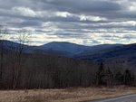
The view just below the summit is tremendous, one of the famed Catskill overlooks. And there’s Joe. He doesn’t see me. I nonchalantly address him, and he replies in like fashion. Then it hits him that it’s me. After all, those guys had written me off when they arrived at McKinley, since they never got my text. And now they need to continue their 10-mile outing. Heading down to the four-way junction, Joe and I bat the conversation back and forth much faster than our hiking pace, as the others fly out of sight.
With their sandwiches out at the intersection, we discuss a variety of Catskill topics. One of these is the call to create marked trails on the trailless high peaks. We span and occupy the varying viewpoints on this likely change. Realizing that it won’t happen overnight, we exchange good-byes as they hike up and I begin the trot down. Descending the hollow, I reflect on the many reasons, excuses, and challenges that bring us to the mountains. Perhaps none is more appreciated than someone reaching out and asking you to go.
Peter Manning is the executive director of the Catskill Mountain Club. To learn about CMC events, membership, and projects visit catskillmountainclub.org.