
Many years ago, in one of those free Pennysaver periodicals (the kind you’d grab at the grocery store), you’d see events and recreation destinations listed for the region. While the event listings would change each week, the ‘places to go’ would typically remain in the publication for long periods of time. Out of the myriad hiking opportunities the region offers, only a small handful of locations were mentioned, thereby placing emphasis on the ones chosen. For a hiking destination, Stony Clove Notch was faithfully posted for months, even years on end. Other than location, no additional information was given.
I always wondered what kind of experiences and stories this listing may’ve generated. While having little information can enhance adventure; we could just as well say the curious traveler could be in for some surprises. Let’s face it, the nine-mile drive up the Stony Clove on Route 214 from Phoenicia is to enter a scenic canyon that culminates at the precipitous V-shaped notch, aka your hiking destination. For even the most ardent of mountain trampers, the climb out of the notch to Plateau Mountain (on the Devil’s Path) is gonna burn some matches, as they say. Gaining 1700 feet in 1.3 miles, this is a real calves-of-steel affair. Just the thought of putting a trail here in the first place still boggles minds many decades after it was built. For many hikers, this is exactly the sort of workout being sought, and especially because there’s an astounding view at the top.
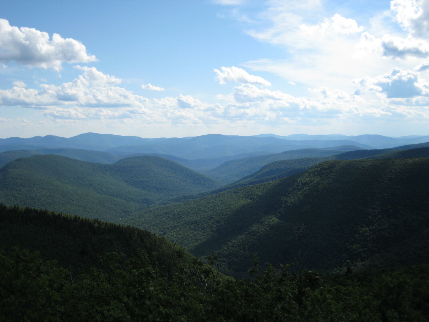
Just before the view there is one final climbing move to be made to get on the ledge. Nothing too crazy, but I mention this in recalling a time when a hiker in another party was having difficulty making the move. After a few attempts, she resigned, stating contentment with her position just below the ledge. Of all the people there, not one of us was going to have any part in her staying below the ledge. With her eventual consent, we nudged her up onto Orchard Point, one the most beloved viewing ledges in the Catskills. Part of what we enjoy so much about this view is its inward-looking, sweeping gaze into undisturbed wilderness. With barely a trace of human evidence before you, this is one of the places in the Catskills that delivers that certain limitless quality of mountainous space. And unlike the more jagged, bare-rock peaks of other ranges, the softer, undulating Catskills, with their vegetated, recumbent ridgelines often elicit a corresponding effect within those who climb them.
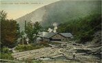
Despite the somnolent vibes we may enjoy today, there were periods in history where Rip, or anyone else looking to catch a few z’s, would’ve had some challenges in dozing off. Not only were there hemlock bark harvests, but the peaks and ridges in the Stony Clove experienced some major logging operations. Being vaguely aware of these activities, my curiosity was prodded after my brother attended a talk by Rick Brooks about the activities of the Fenwick Lumber Company (of Fenwick, WV) in and above Stony Clove. Coincidently, our sister lives in Fenwick, WV (population 116 as of 2010). My brother made it a point to investigate any history of the company and its connection to the Catskills upon his next visit to Fenwick. He made several inquiries but came up with nary a lead. For my part, the investigation began at the base of Myrtle Brook in the Stony Clove, a primary hub of bygone Fenwick activities.
In scampering up the gullies of Myrtle Brook, and other ravines of the high Catskills, my state-of-mind is easily transposed to that of a good ‘side-hilling’ adventure in West Virginia. Marching up alongside Myrtle Brook, we arrived at the location of the former Fenwick Co. works (pictured). Even better, we happened upon one of those high waterfalls that are tucked away in the secluded, shady nooks of the Catskills. Approaching, we encountered a zone of greenery dotted with bright wildflowers thriving in the mist of the falls, as dappled rays of sunlight danced upon each moment of the living scene. Heading up left, with arms and hands now being necessary, we climbed a steep, deliberately made gully that must’ve hosted thousands of logs just over a century ago. Whether this was part of the inclined railway or a log chute is an interesting question. But it is not to be pondered for long when your main priority is to ascend this rocky bobsled run that is seemingly coming out of the heavens. And then it’s all over in an instant -- stepping out of the chute and upon the comparatively level ground of Devil’s Acre.
Though this steep-to-flat topographical sequence is perhaps most accentuated at this location, it is repeated throughout the 24-mile Devil’s Path. For example, going back to Orchard Point, once you pull yourself up onto the ledge, there is a two-mile section of fairly flat trail that stretches across the aptly named Plateau Mountain. It’s like a victory lap or a gift for making the climb; getting to stroll through the woods peacefully above 3500’ for an extended distance. Of course, at the other end of the mountain, there is a view to Sugarloaf Mountain, and then a wild rocky descent into Mink Hollow.
The third trail approach to Plateau Mountain is the Warner Creek Trail. Gentler in gradient than the Devil’s Path, this newer trail (located off Edgewood Road) is often hiked as part of a point-to-point route, with Stony Clove Notch being the other point. This route could also be extended into a loop, though that would entail walking alongside Route 214 for 1.4 miles. The Greater Catskill Region Outdoor Recreation Plan calls for building a connector trail in the woods. Just imagining that the hiking experience could be further enhanced by eliminating a road walk brings a motivation that I express by raising a hand to help make that a reality.
Note, parking at Stony Clove Notch may come with a seasonal fee.
Peter Manning is the Executive Director of the Catskill Mountain Club. To learn about CMC events, membership, and projects visit catskillmountainclub.org.